ANTIGO, WI (WAOW/CNN) – Drones are becoming a popular aid in selling homes and fighting fires, but over the weekend, a drone led the way as hundreds of volunteers searched for a missing 3-year-old boy. The child is home safe.
“(The) sheriff’s department called us and we headed out right away first thing in the morning,” Cameron Berg of Unmanned Systems Inc. said.
“It was a very valuable resource,” Langlade Co. Sheriff Bill Greening said.
As 400 volunteers gathered in Deerbrook in search of missing Dyton Logalbo on Sunday, a tiny aircraft helped organize the search efforts.
“We had all of the ground search teams walk directly to the drone as means of walking in a straight line,” Berg said. “Once they got to the drone, they’d spread out. We’d fly the drone to another spot.”
“(It) helped direct volunteers. (It) helped with the oversight of the entire field we were looking in,” Greening said.
Berg said the boy may have been found much sooner, but the equipment he needed, a thermo cam, was at a testing facility in Montana.
He said unmanned aircraft could be the law enforcement tool of the future.
“Drones are a lot more cost effective,” Berg said. “In the long run, they’re a lot more capable of doing these smaller jobs like this.”
The sheriff agrees.
“A department our size, there’s no way we could afford a helicopter or an airplane for that matter. But yeah, these would be the next best option,” Greening said.
In fact, the sheriff’s department already has a plan to go more high tech.
“We (have) begun the process of looking at purchasing drones for our agency,” Greening said. “We would train their deputies on how to use drones. In the long run, I think that would be the smartest thing to do so they have them on hand whenever they need them.”
Two thirds of fire services in the UK and half of police forces are now using drones or are planning to, Sky News has learned.
Specialist ambulance crews, or Hazard Area Response Teams (HART), are also expected to be equipped with unmanned aerial vehicles (UAVs) this year.
The aim is to enhance working capability. Drones are already being used for search and rescue operations, and fire and accident investigations.
The Mid and West Wales Fire Service has been given Welsh government funding for some of their UAVs.
Steve Richards, the service’s station manager, has been trained as a drone pilot and says drones will save lives.
He added: “It gives you the whole picture so when you go to an incident with (drones) we can actually do a 360 observation and stay in a safe place… it’s putting the drone up instead of having to put the firefighters in there.”
UAV training company Sky Futures has trained 12 different emergency services in drone use since September.
Frankie Suarez, a drone pilot trainer for Sky Futures, said their programmes have had to evolve due to greater collaboration between police, fire and ambulance crews.
He said: “Initially we made scenarios specifically for each service but after a couple of courses we realised they were all interlinking and working together so we managed to develop scenarios that are relevant to what the guys will attend to.
“We have a marauding gunman terrorist scenario, which is fairly relevant these days, as well as a train crash, a downed aircraft, and a missing Alzheimer’s patient, among others.”
Sean Lloyd, station manager at Mid and West Wales Fire Service, said crews have been doing national training exercises alongside police.
“We have the (drone) resources so they use us. When we do get called upon, if we can go and save someone going across the line and getting shot, then why not use us?”
Hundreds of thousands of pounds is being spent in total, equipping frontline emergency staff.
Sussex and Surrey police forces, for example, have been given almost £250,000 from the Home Office to expand on a drone trial at Gatwick Airport.
Sussex Police told Sky News the money comes from the Police Innovation Fund which “rewards creative, collaborative and cost saving projects” aimed at transforming policing.
“The funding is being used to purchase a number of drones to evaluate their contribution to improving policing across the country,” it said.
Other UK police forces have also been using drones in operations for months.
Damian Sowry, Chief Inspector for West Mercia and Warwickshire police services, says he is hopeful their joint trial will demonstrate value for money.
“I’m expecting to be able to show that we can use these devices to protect the public… in a way that’s cost effective and really helps public confidence,” he said.
“Also that we can demonstrate to the public that we take very seriously the issues around privacy, human rights, and all those other kind of concerns that people legitimately have.”
Drone technology was used by police and fire officials Thursday to measure whether residential evacuations would be necessary during Thursday’s seven-alarm fire at a Gurnee propane-storage facility.
As of late Friday afternoon, fire officials had not released a suspected cause or damage estimate for the blaze at Pinnacle Propane Express. Gurnee Fire Department Lt. David Douglass said it appeared most of the damage occurred to propane tanks and their storage area as opposed to the building where the company’s staff works.
“The building is standing,” Douglass said, adding that company staff was at the site Friday, although the business was not operational. Gurnee Mayor Kristi Kovarik said Friday corporate officials from the operation’s business headquarters in Irving, Texas, made the trip to Gurnee to help assess the situation.
While the fire was raging Thursday afternoon, Gurnee police used a drone to monitor to measure the temperature of two large propane tanks on the property and determine that evacuation of nearby neighborhood residents was not necessary, according to Gurnee Fire Chief Fred Friedl.
Explosions rang out as propane tanks blew up during the fire, one of which was launched from the site and hit the wall of a neighboring business, Kovarik said.
The fire at the storage facility, located at 3895 Clearview Court, was serious enough to bring out firefighters from 30 departments and close surrounding roads, including Route 41, for several hours Thursday afternoon.
About a dozen employees had safely exited the facility, and nearby businesses were also evacuated.
The state Fire Marshal’s Office has not been brought in to the investigation, which is being handled by the Gurnee Fire Department. Investigators were working the scene Friday, Douglass said.
“There are no preliminary causes (to announce),” Douglass said Friday.
Kovarik said Friday that the storage business was one of the facilities in the village that police, fire and public works officials realized could be a potential danger, and plans were in place to address the fire when it broke out Thursday.
“We had identified it as a high-risk business,” she said.
The police and fire response “was so swift and organized,” Kovarik said. “I was extremely proud of them.”
Friedl said firefighters used foam on a pile of small propane tanks that ruptured and caused small explosions that added to the fire. The pile of small tanks was near two larger tanks used to refill the cylinders, Friedl added.
“It could have been much worse,” Friedl said. “If either of those (big tanks) would have (ignited), they could have traveled a mile or a mile and a half.”
Route 41 was closed for several hours while the fire was brought under control. Employees were allowed to return to a neighboring business by 4:30 p.m.
Pinnacle Propane Express representatives said they were working with authorities to help determine what caused the fire and reduce the risk of future incidents. They also praised the work of Gurnee responders and those from other departments.
HALF MOON BAY, Calif. — From a bluff overlooking the Pacific Ocean, a loud pop signals the catapult launch of a small fixed-wing drone that is designed to carry medical supplies to remote locations almost 40 miles away.
The drones are the brainchild of a small group of engineers at a Silicon Valley start-up called Zipline, which plans to begin operating a service with them for the government of Rwanda in July. The fleet of robot planes will initially cover more than half the tiny African nation, creating a highly automated network to shuttle blood and pharmaceuticals to remote locations in hours rather than weeks or months.
Rwanda, one of the world’s poorest nations, was ranked 170th by gross domestic product in 2014 by the International Monetary Fund. And so it is striking that the country will be the first, company executives said, to establish a commercial drone delivery network — putting it ahead of places like the United States, where there have been heavily ballyhooed futuristic drone delivery systems promising urban and suburban package delivery from tech giants such as Amazon and Google.
“The concept of drone ports is something that a very small decision-making unit in the country decided they were going to do,” said Michael Fairbanks, a member of the Rwandan president Paul Kagame’s presidential advisory council. “It took a very short time. It’s something that America could learn from.”
That Rwanda is set to become the first country with a drone delivery network illustrates the often uneven nature of the adoption of new technology. In the United States, drones have run into a wall of regulation and conflicting rules. But in Rwanda, the country’s master development plan has placed a priority on the use of the machines, first for medicine and then more broadly for economic development.
“Rwanda has a vision to become a technology hub for East Africa and ultimately the whole continent of Africa,” said William Hetzler, a founder of Zipline, which is based in this seaside town. “Projects like ours fit very well with that strategy.”
The new drone system will initially be capable of making 50 to 150 daily deliveries of blood and emergency medicine to Rwanda’s 21 transfusing facilities, mostly in hospitals and clinics in the western half of the nation.
The drone system is based on a fleet of 15 small aircraft, each with twin electric motors, a 3.5-pound payload and an almost eight-foot wingspan. The system’s speed makes it possible to maintain a “cold chain” — essentially a temperature-controlled supply chain needed to provide blood and vaccines — which is often not practical to establish in developing countries.
The Zipline drones will use GPS receivers to navigate and communicate via the Rwandan cellular network. They will be able to fly in rough weather conditions, enduring winds up to 30 miles per hour.
When they reach the hospitals, they will not land but will drop small packages from very low altitudes. The supplies will fall to earth suspended by simple paper parachutes. The planes will then return to a home base, where they will be prepared for a new mission by swapping in a new battery and snapping in a new flight plan stored in a SIM card.
Zipline’s fixed-wing drone. The pilotless planes will be used to deliver medical supplies in a pioneering commercial network.
“This is the new face of the aerospace industry,” said Jay Gundlach, president of FlightHouse Engineering, an Oregon-based aviation consulting firm. “Established unmanned aircraft companies should learn from Zipline’s agile and innovative culture.”
Like Zipline, others are trying to solve the problem of the autonomous distribution of medical supplies. Many other systems being developed, however, are based on less-efficient multicopter or quadcopter designs that have shorter range and less ability to fly in all-weather situations.
In the United States, a firm named Flirtey has delivered medical supplies using multirotor helicopters as an experiment in Virginia. Another Silicon Valley start-up, Matternet, is experimenting with the government of Malawi and with Unicef to deliver infant H.I.V. tests by quadcopter. Google X, the advanced research arm of Alphabet, is now developing a vertical-takeoff-and-landing system that will hover and deliver packages by the use of winches.
Zipline began in 2014 when two of its founders, Keller Rinaudo and Mr. Hetzler, visited a young public health worker in Dar es Salaam, Tanzania. The worker had created a text-messaging system that enabled hospital workers to urgently request medical supplies in life-or-death situations.
But Mr. Rinaudo said he realized that what he was looking at was a long list of death sentences. Today in many places worldwide, attempts are made to deliver medical supplies by motorcycle or pickup truck over roads that are frequently impassable.
The public health worker “showed me the database that had entries every time someone texted, and it was thousands of names long,” Mr. Rinaudo said. “It was mostly infants, and there was no response. The supply chain had no way of taking them into account.”
Mr. Rinaudo and Mr. Hetzler set about to find an airborne alternative to automate a supply chain. They met Keenan Wyrobek, a Stanford-trained roboticist who was instrumental in the design of the PR1 robot, a pioneering general purpose mobile robot with arms, and later the more advanced PR2 robot developed by Willow Garage.
The three technologists assembled an engineering team with aerospace industry experience, attracting talent from Space X, Aurora Flight Sciences, Boeing and Lockheed Martin, as well as Stanford and Google. The start-up has raised $18 million from investors including Sequoia Capital, GV (formerly Google Ventures), SV Angel, Subtraction Capital, Stanford University and individuals including Jerry Yang, a founder of Yahoo, and Paul Allen, a founder of Microsoft.
Mr. Hetzler said that by placing engineers who have consumer electronics expertise in close collaboration with roboticists and aerospace engineers, it had been possible to rapidly build a highly automated system that would be operated by a staff of five to eight.
In February, Zipline signed a contract with the Rwandan government to begin operating the drone service this summer. A small team will be based in a city near the Rwandan capital of Kigali to oversee the service.
“I always think of Peter Thiel, the venture capitalist, who said, ‘They promised us flying cars and all we got was 140 characters,’” said Paul Willard, a former Boeing aerodynamics engineer who is now an investor in Zipline, referring to the social media service Twitter. “This feels a little bit more like flying cars.”
Bill Kastel and his wife, Tracey, were hoping to catch some extra Sunday morning shuteye when they were awakened early on May 25 by a loud clanking. Opening the front door of the mobile home they’d mounted on five-foot-high stilts near a creek in Venus, Texas, eight years ago, they were astonished to see a river raging below their front porch.
“It was just one foot away from flooding us out,” says Bill, 58, an auto mechanic who was flooded once before in 2007. “The clanking we heard was the pressure tank for our water well after it fell off. If we hadn’t heard it, we probably would have slept through the whole thing.”
Trapped on all sides by water with their cat and five dogs, the Kastels dialed 911 and waited for help. They didn’t expect that help to come in the form of a drone nicknamed “Valkyrie,” operated by software engineer and Joshua Fire Department volunteer Garrett Bryl.
Bryl, 43, a drone hobbyist for three years, offered his services to the rural fire department six months ago when he realized that his quadcopter could make a lifesaving difference when people needed to be found quickly.
“I’d used it before to assist with fires and find gas-line leaks,” Bryl tells PEOPLE, “but this was my first swift-water rescue.”
Using his drone, Bryl delivered life vests and a safety line to the Kastels, which Bill attached to a beam on his house. The other end was then hooked to the bumper of a fire truck and a rescue by raft was attempted.
“They got close, but in the end, it was too dangerous – they were worried about knocking over the stilts on our house and sending the entire place down river,” Kastel tells PEOPLE.
“It’s scary to think that we might have had to leap for our lives or have been washed away,” he says. “Knowing that we had life vests and a safety line made a huge difference. Watching that drone come in was the coolest thing I’d ever seen. That pilot was no rookie.”
An hour or so later, the Kastels were evacuated by a National Guard helicopter, returning once the water had receded to fetch their dogs and cat.
“We were lucky – the damage to our house could have been a lot worse,” says Bill. “I’m so grateful for everybody who showed up to help us, especially the drone pilot. Everybody thinks of drones as something the military uses for spying on people, but there are lots of other uses, too.”
That same morning, Bryl also used Valkyrie to help locate two people trapped in a pickup truck that was swept away by floodwaters near Joshua.
“With an aerial view, I was able to find them in 45 seconds and we got a helicopter in there to get them out before they were carried away by the water,” he says. “All in a day’s work, I guess.”
“Learn from the mistakes of others. You can’t live long enough to make them all yourself.”
–Eleanor Roosevelt
According to industry reports, the UAV sector will see $98.2 billion in total cumulative spending for drones over the next 10 years — $11.8 billion of which will be for non-military commercial drones.
And, while the swarms of new drones buzzing over our heads have the capacity to improve lives, the reality of any emerging technology is that, sooner or later, someone will cause harm through recklessness or ignorance. How can you, the nascent drone pilot, avoid becoming the next cautionary headline? Heed the mistakes of your hapless forebears. Don’t do … this:
The Hague (AFP) – A Dutch-based student on Tuesday unveiled a prototype of an “ambulance drone”, a flying defibrillator able to reach heart attack victims within precious life-saving minutes.
Developed by Belgian engineering graduate Alec Momont, it can fly at speeds of up to 100 kilometres per hour (60 miles per hour).
“Around 800,000 people suffer a cardiac arrest in the European Union every year and only 8.0 percent survive,” Momont, 23, said at the TU Delft University.
“The main reason for this is the relatively long response time of emergency services of around 10 minutes, while brain death and fatalities occur with four to six minutes,” he said in a statement.
“The ambulance drone can get a defibrillator to a patient within a 12 square kilometre (4.6 square miles) zone within a minute, reducing the chance of survival from 8 percent to 80 percent.”
Painted in emergency services yellow and driven by six propellers, the drone can carry a four kilogramme load — in this case a defibrillator.
Graduated TU Delft student Alec Momont shows his design of an ambulance drone with a built in defibrillator in Delft, Netherlands, on October 28, 2014 (AFP Photo/Bas Czerwinski)
It tracks emergency mobile calls and uses the GPS to navigate.
Once at the scene, an operator, like a paramedic, can watch, talk and instruct those helping the victim by using an on-board camera connected to a control room via a livestream webcam.
The prototype has already attracted the interest of emergency services including that of Amsterdam, the Dutch daily Algemeen Dagblad said.
The Dutch Heart Foundation also applauded the idea, the newspaper added.
Momont however wants his drone to become a “flying medical toolbox” able to carry an oxygen mask to a person trapped in a fire or an insulin injection to a diabetes sufferer.
However, the drone is still in its infancy as far as developing its steering mechanism and legal issues regarding its use are concerned, Momont said.
He said he hopes to have an operational emergency drone network across the Netherlands in five years.
The drone is expected to cost around 15,000 euros ($19,000) each.
“I hope it will save hundreds of lives in the next five years,” Momont said.
Earlier this month, first responders in China used drones to determine the hardest-hit areas following a massive earthquake that killed more than 600 people, in one of the first displays of how drones can be used during emergency situations.
One of the great promises of drones is the technology’s inherent ability to be flown above a disaster site, giving first responders a survey of the situation and allowing them to direct where to send aid to. But, until now, that’s been more of a theoretical benefit of drones—very few people have actually used them in the immediate aftermath of a disaster. Take, for instance, the aftermath of Typhoon Haiyan last year in the Philippines: Tons of search and rescue helicopters, but not a single drone, searched for survivors.
Well, after an earthquake hit Yunnan, China, earlier this month, rescue workers there called up Hong Kong’s DJI (the largest commercial drone manufacturer in the world), and asked its pilots for help.
“We sent a team of pilots to assist the China Association for Disaster and Emergency Response Medicine following the earthquake. This was the first time [the country] used [drones] in its relief efforts and as a result many of the cooperating agencies and bodies working on site have approached us for training / using UAS technology in the future,” Michael Perry, a spokesperson for the company, told me in an email.
Perry said that the drones were able to relay images back to rescue workers, who used them to determine which roads needed to be cleared first and which areas of the rubble to search for possible survivors.
“Aerial images captured by the team were used by workers in the epicenter area of Longtoushan, where most of the traditional buildings in the area collapsed,” the company said. “The dense rubble and vegetation have made ground surveying extremely difficult, so using aerial images has helped identify where relief teams can focus on searching for survivors.”
It’s not clear if the drones directly helped save any lives (and granted, everything we know about the aerial imaging effort in this case is coming from the company itself), but this is clearly the future of disaster relief.
Drones are cheap, can be flown close to the ground, and are safer to use than helicopters. It’s only a matter of time until the very first response by first responders is to toss a drone in the air to get a survey of the situation. After that, they just might toss a drone in the air to help deliver medicine and supplies.
When Virginia resident Guillermo DeVenecia went missing last Wednesday, police and searchers were dispatched to find the 82-year-old man, who suffers from dementia and hearing loss.
For three days, police, search dogs, a helicopter, and hundreds of volunteers combed heavily wooded areas and fields around DeVenecia’s Fitchburg home to no avail. Concerned for his safety as the search dragged on, Fitchburg police issued a news alert to all residents to be on the lookout for the missing man.
It took David Lesh about 20 minutes to find DeVenecia with a drone.
Lesh usually uses his drone to photograph skiers and snowboarders for his Colorado sports-apparel company, Virtika. Hearing about the missing man, Lesh, his girlfriend, and her father took to the skies on Saturday above a 200-acre soybean field to aid in the search.
“I thought what would happen would be we’d be able to give them the peace of mind to cross of some more areas quickly,” Lesh’s girlfriend, Katie Gorman, told local NBC news affiliate WMTV.
According to Gorman’s father, Gary, he didn’t think at the time that they’d find DeVenecia alive and safe.
“To be honest, when David was flying the drone over the bean fields, we thought we were looking for a body,” he told reporters.
Using a FPV, or first-person-view controls, Lesh was able to fly above about 200 feet above the area and view it through the drone’s camera. He canvased the field, which might have taken volunteers many hours, in just a handful of minutes.
At the end of the flight around 1 p.m., Lesh said he saw DeVenecia through his camera, standing in the bean rows.
“As we were making the last turn to fly it, we noticed a man out in the field sort of stumbling, looking a little disoriented,” Lesh told reporters.
Lesh and his group carried DeVenecia out of the field and drove him to the local search command center and his worried wife.
“To get a hug from someone’s wife when they’ve been missing, just a tear-filled hug, is a feeling I won’t forget for a long time,” Katie Gorman told reporters.
Despite being without food, water, or shelter for three days, DeVenicia was found in good condition, suffering only from some mild dehydration, according to police. Reports indicate that he had no idea he’d been gone that long or that a massive search was underway.
Archaeologists flew a drone over an ancient site called Blue J in northwestern New Mexico to obtain aerial thermal images of the site.
Thermal images captured by an small drone allowed archaeologists to peer under the surface of the New Mexican desert floor, revealing never-before-seen structures in an ancient Native American settlement.
Called Blue J, this 1,000-year-old village was first identified by archaeologists in the 1970s. It sits about 43 miles (70 kilometers) south of the famed Chaco Canyon site in northwestern New Mexico and contains nearly 60 ancestral Puebloan houses around what was once a large spring.
Now, the ruins of Blue J are obscured by vegetation and buried in eroded sandstone blown in from nearby cliffs. The ancient structures have been only partially studied through excavations. Last June, a team of archaeologists flew a small camera-equipped drone over the site to find out what infrared images might reveal under the surface.
“I was really pleased with the results,” said Jesse Casana, an archaeologist from the University of Arkansas. “This work illustrates the very important role that UAVs (unmanned aerial vehicles) have for scientific research.”
Casana said his co-author, John Kantner of the University of North Florida, had previously excavated at the site and the drone images showed stone compounds Kantner had already identified and ones that he didn’t know about.
For example, the thermal images revealed a dark circle just inside the wall of a plaza area, which could represent wetter, cooler soil filling a kiva, or a huge, underground structure circular that would have been used for public gatherings and ceremonies. Finding a kiva at Blue J would be significant; the site has been considered unusual among its neighbors because it lacks the monumental great houses and subterranean kivas that are the hallmark of Chaco-era Pueblo sites, the authors wrote in the May issue of the Journal of Archaeological Science.
The images also could guide archaeologists’ trowels before they ever break ground.
“Now that we know what household compounds look like in thermal imaging, we could use it to prospect for structures at other sites,” Casana told Live Science.
How it works
Archaeological features like bricks and stone walls retain and emit warmth differently than the surrounding soil, meaning heat maps can provide an outline of rubble buried underground. Casana said archaeologists have been talking about using thermal imaging technology to probe ancient sites for decades, but it’s been almost impossible to operationalize.
“To do it, you need to get a really high-resolution thermal image collected at the right time of day,” Casana said. “It involves tasking a plane with a very expensive sensor to fly at a very low altitude, and that’s just not something that archaeologists could afford.”
Casana primarily studies archaeology of the Middle East and was leading a dig in Syria until civil war broke out in the country in 2011. In 2012, he got a Start-Up grant from the National Endowment of the Humanities to study aerial thermographic imaging. Casana has been investigating archaeological sites with an eight-rotor CineStar 8 remote-controlled copter, which he built from a $6,000 kit a few years ago. So far, he has tested the technology at a site in Cyprus, a Plains Village settlement in South Dakota and the ancient city of Cahokia near modern-day St. Louis, among others. He said he would be taking the craft to Iraq this summer for a new project in Kurdistan.
The uncertain future of drones for science
Archaeologists and other scientists who want to study the Earth from above are increasingly looking at drones as a research tool as the cost for unmanned aerial vehicles, or UAVs, goes down. But the technology is hardly perfect, and there are legal hurdles, too.
“People who fly them for fun say it’s not a question of if you’ll crash it, but when and how badly,” Casana said. He found that to be true in his trials. Hardware sometimes comes loose mid-flight and the software on the ground occasionally freezes, Casana said. He travels with replacement parts and backup systems like balloons and kites.
Meanwhile, the lack of regulations for UAVs in the United States makes it difficult to implement the technology just yet.
The Federal Aviation Administration has set a goal to implement commercial drone regulations by 2015 and recently designated six drone-testing centers across the country to research how UAVs could be safely introduced to U.S. skies. FAA officials have held that it is illegal to fly commercial drones until they write those rules, though they suffered a setback last month when a judge for the National Transportation Safety Board overturned the FAA’s decision to fine a man $10,000 for using a drone to shoot a promotional video, Bloomberg News reported.
To comply with these legal gray areas, Casana said he had to rely student volunteers to operate the drone in New Mexico this summer. (“Hobbyists” have no problem flying the aircraft.) He expressed concern that debates about drone use often ignore scientific applications.
“When legislators think about use of technology, they often don’t think about science,” Casana said. “They need to come up with some regulations. Until they do, it’s really kind of hamstringing science.”
When you hear the word “drone,” you may think of war and surveillance. But as relief efforts in the Philippines after super typhoon “Haiyan” have shown, the unmanned aircraft can also help save lives in times of crisis.
Mark Rösen’s greatest pride weighs about two kilograms, can stay in the air for up to 20 minutes and bears the cryptic name “AscTec Falcon 8.” What appears to be a model helicopter is actually a high-tech drone produced by the German company Ascending Technologies and outfitted with eight propellers, a GPS tracking device and a high-resolution camera.
Rösen has been working for the German aid agency I.S.A.R. (International Search and Rescue) for many years. He first deployed the drone – which was made available for free by Ascending Technologies – while working as a relief worker in the Philippines.
Up-to-date imagery
“The drone enabled us to film the area from the air and determine which streets were passable. We no longer needed to send anybody out to scout the area,” Rösen said, adding that the team was relieved by this, as exploring a disaster zone without the help of up-to-date imagery can be very risky and time-consuming.
The AscTex Falcon 8 drone can take high resolution images
I.S.A.R. Germany specializes in search and rescue operations and is on standby in the case of a building collapse, explosions, earthquakes, floods or storms anywhere in the world. In the Philippines, Rösen’s team was mainly responsible for providing medical assistance to the victims. His organization sent a total of 39 doctors, paramedics and assistants late November to Palo, a city located some ten kilometers south of Tacloban – one of the areas hardest hit by Typhoon Haiyan, aka. Yolanda. Rösen and his team were able to treat more than 2400 people over a period of roughly two weeks.
When it comes to saving human lives, every second counts. But official satellite imagery of the affected areas is often not made available on time, according to Rösen. “It can take hours until a satellite is repositioned.” But things are different with the drone, he says. Once airborne, the drone transmits images to a ground station within seconds, and these images are often sharper than the ones provided by satellites, as they were taken from a much shorter distance, Rösen adds. With a 24-megapixel resolution, the pictures are said to be so detailed that one can even identify license plate numbers.
The drone sends back pictures to a ground station which are then compared to Google Maps images
Matching data with Google Maps
In the Philippines, Rösen and his colleagues transferred the areal photographs taken by the drone to a computer and then compared these to images from Google Maps.
With the help of coordinates they were then able to assign the operational areas and forward this information to other aid agencies. This allowed the team to make quick decisions as to where the best places to set up field hospitals would be. The images led the team to settle in a square right next to the cathedral of Palo. The mostly undamaged building lies in the center of town and could be easily reached by residents.
No approval required
But quick access to high resolution images is not the only advantage provided by the drone. It also helps elude an autocratic hurdle: “One can deploy the drone without the need to get anyone’s approval. And after a day of training everyone is capable of steering the aircraft,” says Matthias Beldzik, Ascending Technologies’ marketing chief.
The manager says the AscTec Falcon 8 is capable of withstanding winds of up to 10 meters per second. However, rain weather limits the drone’s capabilities: “When filmy under heavy rain, the camera lens gets wet, the rotor blades swirl the rain drops even more, thus worsening visibility,” said Rosen.
Looking for casualties
The Swiss firm Danoffice IT also provided two reconnaissance aircraft for the relief efforts in the Philippines. Engineer Liam Dawson traveled late November to the Southeast Asian country with two “Huginn X1” drones to assist aid organizations on the ground. One feature of the device turned out to be very useful:
“Our drone carries a thermal imaging camera, which can help us detect people in the rubble who are still alive,” Dawson explained. The drone was also used for tracking down bodies: “There were many corpses floating in the ocean after the typhoon. The drone assisted us in locating them,” Dawson added.
Rösen and his team were able to steer the drone after a day of training
A small, but pricey device
While the drones may be useful, these flying helpers come at a high price. With a range of up to eight kilometers, the AscTec Falcon 8 costs about 31,000 USD (23,000 euros) and the Huginn X1- with four propellers and a range of up to ten kilometers – is available for 49,000 USD (36,000 euros). Furthermore, the Huginn X1 fly at over 9849 feet (3,000 meters) and weighs only have as much as the AscTec Falcon 8.
Engineer Dawson justifies the high price by saying: “The drone can help you save time and lighten your workload. This enables aid workers on the ground to do other type of work.” Rösen sees a big future for the gadget: “It will remain part of our resources. From now on we will take the drone to every area we operate in.”
As Direct Relief’s relief and recovery efforts in the Philippines following Typhoon Haiyan continue, civil drones are helping our organization and others respond more efficiently to the most pressing needs of people affected by the super storm.
About a week after Typhoon Haiyan struck, an assessment group from Direct Relief’s partner, veterans’ response organization Team Rubicon, sought to determine the operational status of the Carigara District Hospital, located northwest of the city of Tacloban.
Travel along damaged roads was difficult and slow. Rumors of an uncertain security situation were circulating. Comprehensive structural assessment seemed highly challenging at best.
Yet, the assessment group was able to provide local officials and aid groups with a rapid and highly accurate visual analysis of damage to the Carigara District Hospital – at minimal risk to the people conducting the assessment – by deploying the latest in close proximity aerial imaging technology with a Huginn X1 civil drone.
The assessment provided enough information to allow Team Rubicon to proceed with setting up a medical relief station there to help survivors access emergency care. Direct Relief has been supporting Team Rubicon’s medical responders on the ground with critical medicines and supplies.
A civil drone is the peacetime and humanitarian cousin of the aerial robotic units which have been discussed extensively in the press throughout several recent US-led military conflicts. The Huginn X1, manufactured by Anthea Technologies and distributed by DanOfficeIT, is a ruggedized quadcopter drone adapted primarily for search and rescue support. It comes equipped with high definition digital cameras as well as thermal imaging to detect the heat signatures of people on the ground who may be in need of help.
DanOfficeIT contributed the drone technology and manpower free of charge to nongovernmental organizations working on the front lines of the typhoon response to help organizations learn where to focus their work.
Civil drones have had an immediate and substantial impact on the ability of groups like Direct Relief and Team Rubicon to gain high-speed visual awareness of complex situations that threaten to put humanitarian responders at significant personal risk.
Likewise, civil drones allow for detailed aerial mapping in support of operational planning. The Huginn X1 was not only valuable in terms of structural assessment but also as a way to scout locations in advance to determine the best possible routes of approach and assistance.
While policy, procedural, and technical challenges remain, current work in the Philippines foretells a future where humanitarian responders may be able to collaborate closely with advanced robotic tools to improve the speed, accuracy and safety of response efforts.
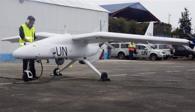
(Reuters) – United Nations forces in Democratic Republic of Congo launched unmanned aircraft on Tuesday to monitor the volatile border with Rwanda and Uganda, the first time U.N. peacekeepers have deployed surveillance drones.
The aircraft will be used to look out for threats from a host of local and foreign armed groups in the mineral rich east where Congo and U.N. experts have accused Rwanda and Uganda of sending arms and troops to back the recently-defeated M23 rebels, something both countries deny.
“The drones … will allow us to have reliable information about the movement of populations in the areas where there are armed groups,” U.N. Under-Secretary-General for Peacekeeping Operations Herve Ladsous said at the launch of the drones in Goma, the largest city in eastern Congo.
“We will survey the areas where there are armed groups, and we can control the frontier,” he added.
The U.N. mission has deployed two Falco drones manufactured by Selex ES, a unit of Italian defense group Finmeccanica.
One of the 5-metre (16-ft) long aircraft – painted white with the letters UN in black on its wings and tail – performed a demonstration flight for the crowd at the launch.
The drones will be flown out of Goma by Selex staff. They can fly for between eight and 14 hours and as far as 200 km (125 miles) from their base, according to the company.
U.N. peacekeepers have received widespread criticism for doing too little to end fighting in eastern Congo, a hilly and thickly forested region that Kinshasa has struggled to control during two decades of virtually constant conflict.
But the drone deployment comes after the peacekeepers helped defeat M23, the most serious rebellion of President Joseph Kabila’s 12-year rule.
General Carlos Alberto dos Santos Cruz, commander of the U.N. force in Congo, said the drones would only fly over Congolese territory, as U.N. peacekeepers have no mandate to operate in neighboring countries.
Victory over M23 was the first time Kinshasa had militarily defeated a major uprising in the east. It was helped by strong U.N. support, major reforms in Congo’s army and intense diplomatic pressure on Congo’s neighbors to halt rebel support.
Congo and U.N. experts say foreign backing for M23 was significant. Following the defeat, experts are examining the origin of a significant stash of weaponry and trucks found at M23’s bases in hills along the Rwandan border.
The drones were due to be launched as early as September, in the hope of monitoring the conflict taking place on the border. However delays meant they arrived only after M23 was defeated.
While a final political deal with M23 is still being ironed out, Congolese and U.N. forces are now expected to turn their attention to the Rwandan Hutu FDLR rebel group and Ugandan ADF-NALU rebels, both of which are based in Congo’s east.
Multi rotors perform a lot of useful tasks, but here’s one of the best I’ve ever seen. Henry Evans, who has been paralyzed by a type of stroke, uses a quadrotor to navigate space. The aircraft’s FPV view allows Henry to look around a garden or take a stroll across campus and gives him greater accessibility to the world. This is worth watching!
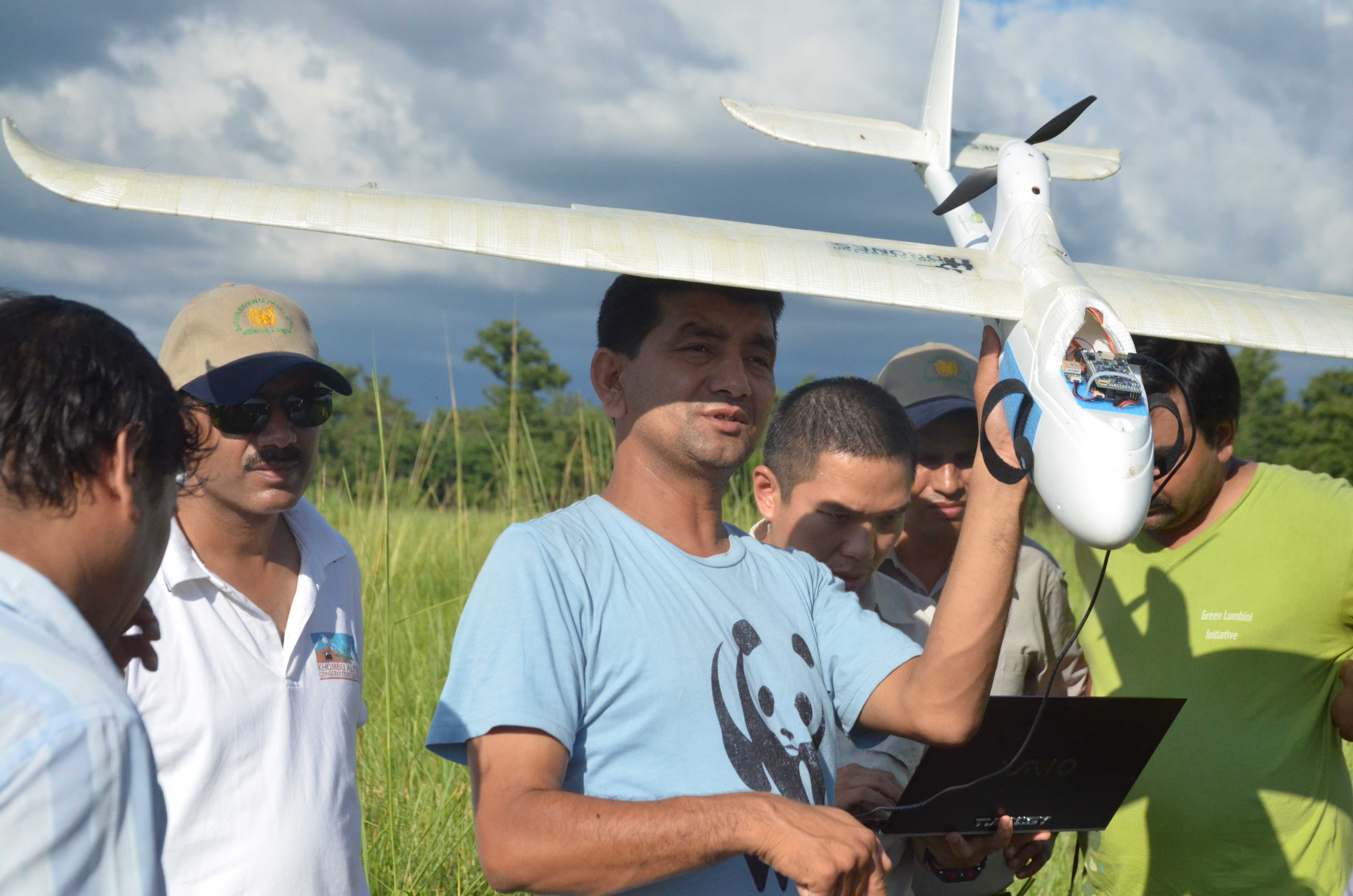
[ For more information about UAV’s positively impacting wildlife, pick up the January/February 2014 issue of Robot Magazine and check out “UAV’s Deployed in Nepal To Save Wildlife”, by Tom Atwood. http://www.botmag.com ]
BARDIA NATIONAL PARK
– Nepal’s antipoaching efforts received a major boost this week as park rangers and army personnel learn how to operate unmanned aerial vehicles (UAVs) in two national parks in a training program organized by WWF.
Nepal is home to rhinos, tigers and elephants, among the world’s most vulnerable species. Poaching of these and many other animals is at an all-time high and the hope is that UAV technology will help capture poachers in the act and deter others from even trying.
WWF has supported Nepal with training rangers to use unmanned aerial vehicles to monitor for poachers.
“Nepal is committed to stopping wildlife crime, which is robbing Nepal of its natural resources, putting the lives of rangers and local communities at risk, and feeding into global criminal networks,” said General Krishna Acharya, Director of Nepal’s Department of National Parks and Wildlife Conservation. “Technologies like these non-lethal UAVs could give our park rangers a vital advantage against dangerously armed poachers.”
Nineteen park rangers and Nepal army personnel were trained to use the UAVs by developer Mr. Lian Pin Koh, an ecologist at the Swiss Federal Institute of Technology Zurich. Participants learned how to use the planes and conducted field tests in Bardia National Park.
Traditionally, effective monitoring of national parks has depended largely on accessibility of the terrain by anti-poaching patrols as well as prior intelligence on poachers in the vicinity.
The UAV gives the patrols a new strategic advantage with an eye in the sky, allowing them access into previously unreachable areas and a safe view of illegal activities on the ground. The presence of a UAV also serves as a deterrent to poachers and illegal loggers since they now know that the parks are being monitored both on the ground and from above.
The GPS-enabled FPV Raptor model planes are light enough to be launched by hand, filming the ground below with a still or video camera. They can fly a pre-programmed route of about 30km at a maximum elevation of 200 meters for up to 50 minutes. The battery can be recharged in about half an hour. Each UAV costs about $2500, making it affordable even for developing countries like Nepal.
“WWF is excited to be part of this field test of new technology in partnership with the government of Nepal,” said Anil Manandhar, Country Representative of WWF Nepal. “We see this as a potentially powerful new tool to improve protection of Nepal’s national parks from illegal activities like poaching and logging.”
This documentary details the bureaucratic challenges faced by search and rescue personnel and their desperate need for civilian drones which are restricted by the Federal Aviation Administration (FAA). Countless lives could be saved with this existing and affordable technology, but the government prohibited their use in 2007.
A drone the size of a small Cessna plane buzzing over the massive Rim fire has become a valuable tool as commanders use its real-time imagery to strategize their next move.
The remotely piloted plane began flying Wednesday morning after Incident Cmdr. Mike Wilkins requested the MQ-1 aircraft belonging to the California Air National Guard. It has since been giving fire commanders a bird’s-eye view of the 300-square-mile blaze in and around Yosemite National Park, which is now the sixth largest fire in state history.
Unmanned aircraft have been used sparingly on fires but are gaining value as a cheaper, more efficient tool for fire commanders to better understand how fires are behaving.
They are prized for their ability to beam real-time pictures directly to fire commanders, who can make tactical adjustments more quickly. The aircraft are equipped with infrared heat sensors and a swiveling camera operated remotely.
During a 20-hour mission Wednesday, the drone — taking off from the Victorville airport and operated from March Air Reserve Base in Riverside — alerted crews to a spot fire and provided a more comprehensive fire map.
Unlike manned planes and helicopters, drones are not grounded at night or unable to fly in high winds or smoke. They fly at about 18,000 feet and cost about $800 an hour to operate, Keegan said.
There are now 4,840 firefighters battling the Rim fire, which has been burning in the Stanislaus National Forest for nearly two weeks.
The blaze is 30% contained and has cost nearly $40 million to fight so far, officials said. The fire has burned about 301 square miles, an area bigger than Chicago or San Francisco, and destroyed at least 111 structures.
Fire crews in Yosemite were hoping to slow advancing flames by conducting large-scale backfire operations from Hetch Hetchy Reservoir south to Tioga Road.
The rate of spread of the massive fire has slowed in recent days and firefighters expect to have it fully contained by Sept. 10, officials said.
Mounties in Saskatchewan are crediting a high-tech drone for the rescue of a man who had walked away from his vehicle after a rollover crash and could not be found.
According to RCMP, the crash happened around 12:20 a.m. CST Thursday on Highway 5, about five kilometres east of St. Denis, Sask., which is about 35 kilometres east of Saskatoon.
Emergency crews were notified of the crash in a 911 call and police, ambulance and other rescue teams were dispatched.
However, when they arrived at the site of the roll over, there was no one in the vehicle.
“The examination of the scene indicated that at least one person had been in the vehicle and was injured,” RCMP said.
A ground search was launched, but after rescuers scoured some 200 metres in all directions, there was still no sign of anyone.
RCMP then called in an air ambulance helicopter equipped with night-vision equipment and high-powered searchlights. The helicopter scanned an area about one kilometre around the crash site, again with no results.
Drones called in.
Finally, about an hour into the search, RCMP called for their drone — an unmanned aerial vehicle with an infrared camera mounted on it.
The drone was at the scene, preparing to launch, when RCMP received a cellphone call from the injured man, a 25 year old.
“He indicated he was cold, did not know where he was and could give no directions to his location,” RCMP said. He was only dressed in T-shirt and pants. He had lost his shoes in the crash.
RCMP said the temperature was near freezing at the time.
Police said they used the cellphone’s signal to get a better idea of the man’s location.
The new search area was a field more than two kilometres south of the rollover.
RCMP officers and rescue people, on the ground and in the helicopter, went to that location but again could not find the man.
Heat source spotted.
Finally, at 3 a.m. the drone was launched and a small heat signature was detected.
Searchers were sent to that heat source, which was about 200 metres from the cellphone’s last GPS ping. RCMP said the cellphone signal stopped transmitting after the last call.
“Fire and rescue members located the driver at this first location, curled up in a ball at the base of a tree next to snow bank,” RCMP said. “He was unresponsive and was quickly brought out to the road.”
He was taken to hospital in Saskatoon for treatment. RCMP said he was released Thursday afternoon.
RCMP said using their drone with the heat-sensing equipment was key in the rescue.
Drone made in Saskatoon
RCMP Cpl. Doug Green, who deployed the drone in the search, told CBC News the machine was built and designed by a Saskatoon company, Draganfly Innovations.
“It’s a small little four-armed helicopter that has the capability of a camera or a FLIR [Forward Looking Infrared] or a low-light camera attachment that has a video link right back to the hand-held controller that I fly it with,” Green explained. “I see exactly what the camera is looking at and I can control the camera up and down.”
Green said the drone used a FLIR camera which detects heat from an object during Thursday morning’s rescue.
He said that in most highway crashes, victims are found near to their vehicles or within about 200 metres.
In Thursday’s case, Green said the man suffered a head injury and was disoriented.
“He just, instead of phoning right away, he wandered off and got lost in the dark,” Green said, adding it was cold, the field had water in it and the wind was picking up. “He was wet and cold.”
Green said the RCMP have been using the Dragan Flyer X4-ES for just over a year in a series of trials to determine how they might assist different elements of police work. Green was equipped with one for use in traffic analysis.
“We’re still just trying out different platforms,” he said, adding that five officers have obtained the necessary training and licences from aviation authorities to fly the devices.