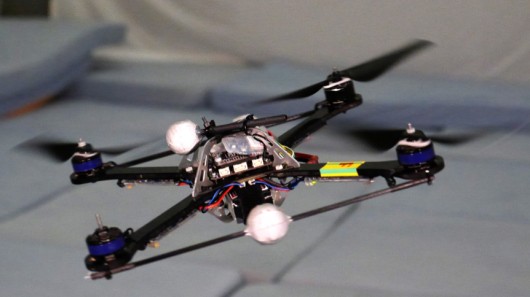
Two thirds of fire services in the UK and half of police forces are now using drones or are planning to, Sky News has learned.
Specialist ambulance crews, or Hazard Area Response Teams (HART), are also expected to be equipped with unmanned aerial vehicles (UAVs) this year.
The aim is to enhance working capability. Drones are already being used for search and rescue operations, and fire and accident investigations.
The Mid and West Wales Fire Service has been given Welsh government funding for some of their UAVs.
Steve Richards, the service’s station manager, has been trained as a drone pilot and says drones will save lives.
He added: “It gives you the whole picture so when you go to an incident with (drones) we can actually do a 360 observation and stay in a safe place… it’s putting the drone up instead of having to put the firefighters in there.”
UAV training company Sky Futures has trained 12 different emergency services in drone use since September.
Frankie Suarez, a drone pilot trainer for Sky Futures, said their programmes have had to evolve due to greater collaboration between police, fire and ambulance crews.
He said: “Initially we made scenarios specifically for each service but after a couple of courses we realised they were all interlinking and working together so we managed to develop scenarios that are relevant to what the guys will attend to.
“We have a marauding gunman terrorist scenario, which is fairly relevant these days, as well as a train crash, a downed aircraft, and a missing Alzheimer’s patient, among others.”
Sean Lloyd, station manager at Mid and West Wales Fire Service, said crews have been doing national training exercises alongside police.
“We have the (drone) resources so they use us. When we do get called upon, if we can go and save someone going across the line and getting shot, then why not use us?”
Hundreds of thousands of pounds is being spent in total, equipping frontline emergency staff.
Sussex and Surrey police forces, for example, have been given almost £250,000 from the Home Office to expand on a drone trial at Gatwick Airport.
Sussex Police told Sky News the money comes from the Police Innovation Fund which “rewards creative, collaborative and cost saving projects” aimed at transforming policing.
“The funding is being used to purchase a number of drones to evaluate their contribution to improving policing across the country,” it said.
Other UK police forces have also been using drones in operations for months.
Damian Sowry, Chief Inspector for West Mercia and Warwickshire police services, says he is hopeful their joint trial will demonstrate value for money.
“I’m expecting to be able to show that we can use these devices to protect the public… in a way that’s cost effective and really helps public confidence,” he said.
“Also that we can demonstrate to the public that we take very seriously the issues around privacy, human rights, and all those other kind of concerns that people legitimately have.”
HALF MOON BAY, Calif. — From a bluff overlooking the Pacific Ocean, a loud pop signals the catapult launch of a small fixed-wing drone that is designed to carry medical supplies to remote locations almost 40 miles away.
The drones are the brainchild of a small group of engineers at a Silicon Valley start-up called Zipline, which plans to begin operating a service with them for the government of Rwanda in July. The fleet of robot planes will initially cover more than half the tiny African nation, creating a highly automated network to shuttle blood and pharmaceuticals to remote locations in hours rather than weeks or months.
Rwanda, one of the world’s poorest nations, was ranked 170th by gross domestic product in 2014 by the International Monetary Fund. And so it is striking that the country will be the first, company executives said, to establish a commercial drone delivery network — putting it ahead of places like the United States, where there have been heavily ballyhooed futuristic drone delivery systems promising urban and suburban package delivery from tech giants such as Amazon and Google.
“The concept of drone ports is something that a very small decision-making unit in the country decided they were going to do,” said Michael Fairbanks, a member of the Rwandan president Paul Kagame’s presidential advisory council. “It took a very short time. It’s something that America could learn from.”
That Rwanda is set to become the first country with a drone delivery network illustrates the often uneven nature of the adoption of new technology. In the United States, drones have run into a wall of regulation and conflicting rules. But in Rwanda, the country’s master development plan has placed a priority on the use of the machines, first for medicine and then more broadly for economic development.
“Rwanda has a vision to become a technology hub for East Africa and ultimately the whole continent of Africa,” said William Hetzler, a founder of Zipline, which is based in this seaside town. “Projects like ours fit very well with that strategy.”
The new drone system will initially be capable of making 50 to 150 daily deliveries of blood and emergency medicine to Rwanda’s 21 transfusing facilities, mostly in hospitals and clinics in the western half of the nation.
The drone system is based on a fleet of 15 small aircraft, each with twin electric motors, a 3.5-pound payload and an almost eight-foot wingspan. The system’s speed makes it possible to maintain a “cold chain” — essentially a temperature-controlled supply chain needed to provide blood and vaccines — which is often not practical to establish in developing countries.
The Zipline drones will use GPS receivers to navigate and communicate via the Rwandan cellular network. They will be able to fly in rough weather conditions, enduring winds up to 30 miles per hour.
When they reach the hospitals, they will not land but will drop small packages from very low altitudes. The supplies will fall to earth suspended by simple paper parachutes. The planes will then return to a home base, where they will be prepared for a new mission by swapping in a new battery and snapping in a new flight plan stored in a SIM card.
Zipline’s fixed-wing drone. The pilotless planes will be used to deliver medical supplies in a pioneering commercial network.
“This is the new face of the aerospace industry,” said Jay Gundlach, president of FlightHouse Engineering, an Oregon-based aviation consulting firm. “Established unmanned aircraft companies should learn from Zipline’s agile and innovative culture.”
Like Zipline, others are trying to solve the problem of the autonomous distribution of medical supplies. Many other systems being developed, however, are based on less-efficient multicopter or quadcopter designs that have shorter range and less ability to fly in all-weather situations.
In the United States, a firm named Flirtey has delivered medical supplies using multirotor helicopters as an experiment in Virginia. Another Silicon Valley start-up, Matternet, is experimenting with the government of Malawi and with Unicef to deliver infant H.I.V. tests by quadcopter. Google X, the advanced research arm of Alphabet, is now developing a vertical-takeoff-and-landing system that will hover and deliver packages by the use of winches.
Zipline began in 2014 when two of its founders, Keller Rinaudo and Mr. Hetzler, visited a young public health worker in Dar es Salaam, Tanzania. The worker had created a text-messaging system that enabled hospital workers to urgently request medical supplies in life-or-death situations.
But Mr. Rinaudo said he realized that what he was looking at was a long list of death sentences. Today in many places worldwide, attempts are made to deliver medical supplies by motorcycle or pickup truck over roads that are frequently impassable.
The public health worker “showed me the database that had entries every time someone texted, and it was thousands of names long,” Mr. Rinaudo said. “It was mostly infants, and there was no response. The supply chain had no way of taking them into account.”
Mr. Rinaudo and Mr. Hetzler set about to find an airborne alternative to automate a supply chain. They met Keenan Wyrobek, a Stanford-trained roboticist who was instrumental in the design of the PR1 robot, a pioneering general purpose mobile robot with arms, and later the more advanced PR2 robot developed by Willow Garage.
The three technologists assembled an engineering team with aerospace industry experience, attracting talent from Space X, Aurora Flight Sciences, Boeing and Lockheed Martin, as well as Stanford and Google. The start-up has raised $18 million from investors including Sequoia Capital, GV (formerly Google Ventures), SV Angel, Subtraction Capital, Stanford University and individuals including Jerry Yang, a founder of Yahoo, and Paul Allen, a founder of Microsoft.
Mr. Hetzler said that by placing engineers who have consumer electronics expertise in close collaboration with roboticists and aerospace engineers, it had been possible to rapidly build a highly automated system that would be operated by a staff of five to eight.
In February, Zipline signed a contract with the Rwandan government to begin operating the drone service this summer. A small team will be based in a city near the Rwandan capital of Kigali to oversee the service.
“I always think of Peter Thiel, the venture capitalist, who said, ‘They promised us flying cars and all we got was 140 characters,’” said Paul Willard, a former Boeing aerodynamics engineer who is now an investor in Zipline, referring to the social media service Twitter. “This feels a little bit more like flying cars.”
Deep learning algorithms have taught these aerial robots how to follow an unfamiliar path.
Autonomous drones have already mastered the wide-open skies. DHL, Amazon, and Google have each demonstrated self-piloting drones that can deliver packages — in fact, the latter two, as The Vergerecently reported, are ready to implement full-scale drone delivery operations in the US and are simply waiting on regulators to get out of the way. But drones that can fly autonomously in complex environments with multiple obstacles (i.e. not the wide-open sky) are another story.
Navigation in terrains that are densely populated with obstacles is an ongoing challenge for researchers. There’s been some headway by a team at MIT, who last November demonstrated an autonomous drone avoiding trees while flying at high speeds in a wide-open field. Now, a group of Swiss researchers have developed technology that allows drones to autonomously navigate forest trails, a development they say could one day aid in search-and-rescue operations.
The group, comprised of researchers from the Dalle Molle Institute for Artificial Intelligence, the University of Zurich, and NCCR Robotics, used deep learning neural networks to tackle the challenge of training an autonomous drone to navigate a densely wooded forest. Teaching a computer to recognize the direction of a trail is a complex task. It can even be difficult for a human to determine the direction of a trail. Just take a look at these photos of trails taken by the researchers and try to determine which direction they’re headed in:
In order to train their algorithm, the researchers mounted three GoPro cameras to a headset and took off on hiking trails across the Swiss Alps. One camera was pointed ahead of the hiker, one to the left, and one to the right. After hours spent on these trails, the researchers had snapped over 20,000 images (images in front of the hiker and on either side). Then they used these images to teach their algorithm what the boundaries of a hiking trail should look like.
The result was a deep-learning algorithm that allows a drone equipped with a single forward-facing color camera to navigate a previously-unseen trail completely on its own — no human interaction whatsoever. The algorithm, the researchers claim, was even better than humans at determining the correct direction of the trails it traveled on, guessing the correct direction of a trail with 85 percent accuracy. Humans tasked with determining the direction of the same trails were able to do so correctly only 82 percent of the time.
The team cautions that these results are still in very preliminary stages. But while there’s a lot more work to be done before autonomous drones will be able to search forests for missing people, the researchers believe their work is a good sign of how deep neural network will allow autonomous vehicles to navigate situations that involve complex and highly dimensional inputs.
Federal regulators said Monday that they plan to require recreational drone users to register their aircraft with the government for the first time in an attempt to restore order to U.S. skies, which have been invaded by rogue flying robots.
U.S. officials said they still need to sort out the basic details of the registration system but concluded that they had to take swift action to cope with a surge in sales of inexpensive, simple-to-fly drones that are increasingly interfering with regular air traffic.
“The signal we’re sending today is that when you’re in the national airspace, it’s a very serious matter,” Transportation Secretary Anthony Foxx told reporters.
Pilots of passenger planes and other aircraft are reporting more than 100 sightings or close calls with rogue drones a month — a significant increase just in the past year, according to the Federal Aviation Administration.
Under FAA guidelines, drone owners are not supposed fly their aircraft above 400 feet or within five miles of an airport without permission. But the rules are widely flouted, and officials have been largely powerless to hunt down rogue drone operators.
Requiring drones to be registered will be of limited use for investigators unless the remote-controlled aircraft crash and a registration number can be found. Most drones are too small to appear on radar and do not carry transponders to broadcast their locations.
But regulators hope that forcing owners — many of whom are aviation novices — to register their drones with the government will at least make them think twice about their responsibility to fly safely and the possibility that they could be held accountable for an accident.
The FAA and the Transportation Department are setting up a task force composed of government officials and industry representatives to devise the new registration system. Foxx said the group has until Nov. 20 to finalize its recommendations so the government can set up the registry before Christmas — the peak season for drone sales.
“We do intend to move very quickly,” he said.
The task force will have to wrestle with the basic question of size limits and what kinds of drones will have to be registered. Most consumer models weigh only a few pounds and resemble toys, but many can easily reach altitudes above 1,000 feet.
Foxx said the registration rules will also apply to people who have already bought drones in recent years, not just new owners. He said the FAA would impose penalties — which he did not spell out — on anyone who does not comply.
Nobody knows exactly how many of the robotic aircraft are flying around, but most estimates top 1 million.
The Consumer Electronics Association, an industry group, estimates that hobbyists will buy 700,000 drones in the United States this year, a 63 percent increase from 2014.
In addition to snarling air traffic, nuisance drones across the country have interfered with firefighters, flown into tall buildings and crashed into bystanders on the ground. Criminals have used them to smuggle contraband into prisons. Some property owners have become so irritated by drones buzzing overhead that they have gotten out their shotguns and opened fire.
In general, the drone misadventures have been taking place in a regulatory vacuum. The FAA has banned most businesses from flying drones until it can finalize new safety rules — a step that will take at least another year.
But hobbyists who fly drones for fun are largely unregulated. Under a law passed by Congress in 2012 to protect model-airplane enthusiasts, the FAA is prohibited from imposing new restrictions on recreational drone owners. As a result, they have not been required to obtain pilot licenses or undergo training.
Although the FAA lacks the authority to license recreational drones, it does have the power to impose civil fines on anyone who recklessly interferes with air traffic or endangers people on the ground. Foxx also said the FAA has the authority to require the registration of any aircraft that fly in the national airspace — manned or unmanned.
This might look like a slightly ramshackle home-brew drone, but in fact its a new kind of robotic vehicle developed bu NASA that “can gather samples on other worlds in places inaccessible to rovers.”
The new drone has been developed by Swamp Works engineers at NASA’s Kennedy Space Center in Florida, and it’s being built as a kind of prospecting robot. “The first step in being able to use resources on Mars or an asteroid is to find out where the resources are,” explains Rob Mueller, who’s been working on the project, in a press release. “They are most likely in hard-to-access areas where there is permanent shadow. Some of the crater walls are angled 30 degrees or more, and that’s far too steep for a traditional rover to navigate and climb.”
So NASA’s solution is what it calls Extreme Access Flyers. These craft, wich seem to resmeble quad-copter drones, would be able to “travel into the shaded regions of a crater and pull out small amounts of soil to see whether it holds the water-ice promised by readings from orbiting spacecraft.” Unlike Earth-bound drones, though, they use gas jets instead of rotors—because the alien atmospheres like those of Mars and the Moon would be too thin to support spinning blades.
Perhaps several of the drones would be taken to the surface of other worlds aboard a lander, which they’d used as a base to fly from using autonomous navigation systems. The lander would also act as a support unit, with the drones relying on it for the replenishment of batteries and propellants between flights. Speaking or propellants, NASA’s hope is to have the drone’s jets run on something like oxygen or steam water vapor — so, in theory, it may even be able to fuel itself from the planet it’s on. Indded, NASA explains just what it may find while its’s there:
In addition to scouting craters for water and other elements that can be processed into fuel for large spacecraft and air for humans, the flyer would be capable of exploring lava tubes that are known to exist on Mars and the moon and are found in many volcanic areas on Earth. Because some are thought to be 30 feet or bigger in diameter, an extreme access flyer could navigate autonomously during a robotic precursor mission and find a safe place for astronauts during their journey to Mars.
While the project started two years ago, the team has been using rapid advances in commercially available drones to keep the work moving at speed. “The flight control systems of small, unmanned multi-rotor aerial vehicles are not too dissimilar to a spacecraft controller,” explains Mike DuPuis, one of the researchers. “That was the starting point for developing a controller.” In fact they’ve already developed several small craft, from a flyer the size of a person’s palm to a large quad-copter about five feet across that uses ducted gas fans to fly.
The latter, NASA claims, is the kind of size of drone that would likely be used on a mission to Mars or the Moon. It’s not yet clear when such a mission might happen, though.
MENLO PARK, Calif. — Facebook on Thursday revealed more details about its plan to find cost-effective ways to provide Internet access to the 10% of the Earth’s population that lives far from cell towers or land lines.
The solution: Drones the size of a Boeing 737 — launched by helium balloons.
Powered by the sun, each 1,000 lb. drone would fly lazy circles more than 11 miles above the Earth, providing broadband-level Internet for people in a 50-mile radius below.
The team’s dream is “a backbone of the Internet using lasers in the sky,” said Yael Maguire, director of Facebook’s Connectivity Lab.
The planes, dubbed Aquila, (Latin for “eagle”) would be unmanned. Each would spend three months aloft before slowly floating down to earth “like a feather” for refit, said Jay Parikh, vice president of engineering at Facebook.
The effort is part of a project launched a year ago by Facebook’s Connectivity Lab to provide Internet access to the 4 billion people around the world who currently lack it.
While many people live in sufficiently connected or urban areas where current methods, such as wires and cellular phones, can provide Internet access, millions of people live where a connection isn’t possible.
“Standard telecommunication infrastructure doesn’t reach them. If they pulled out a phone, it would have nothing to connect to,” said Parikh.
Facebook has set out to find a way to give it to them.
The answer the company’s engineers have come up with involves sending planes that can beam down access far above commercial airspace, where there are no commercial flights to run into and no weather to interfere with flight.
The plane, which is virtually all wing, is about 100 feet wingtip to wingtip.
“If you’re thinking of your little quad copters, this isn’t what we’re building,” said Parikh.
The first test vehicle was built this year by Ascenta, a Somerset, England-based solar drone company that Facebook purchased in 2014.
One of Facebook’s biggest breakthroughs in the project has been increasing data capacity of the lasers that will connect the planes with a land-based fiber line that is the link to the Internet.
Facebook’s team has developed a system whose ground-based laser can transmit information to a dome on the underside of the plane at rates 1,000 times faster than has previously been possible.
It’s something like reading a CD with a laser head just after it’s been thrown into the air like a Frisbee — from 11 miles away.
“The team has figured out how to do a laser communion system that can go tens of gigabits in a second,” Parikh said. “Doing that in fiber is routine, but doing it through the air has never been done.”
None of this means Facebook plans to go into the ISP business, or airplane manufacturing, said Parikh.
“Our intention is not to be an operator here. We want to inspire and get the industry to move faster,” he said.
Facebook’s team plans to spend the second half of 2015 doing structural tests on the one plane they’ve build, “making sure it flies,” said Parikh.
“We still have development to go on the batteries, solar cells and avionics, there are huge challenges, this has never been done before,” said Maguire.
WANT TO GET AN AMBULANCE THROUGH URBAN ENVIRONMENTS FASTER? GIVE IT PROPELLERS AND SPACE FOR ONE PASSENGER.
In emergencies, seconds count. An estimated 1,000 “saveable” lives are lost a year because of slow emergency response in the nation’s biggest cities. But in traffic-jammed urban environments, how can a four-wheeled ambulance be expected to make it anywhere and back quickly?
Design firm argodesign has a wild conceptual solution. It’s a one-person ambulance drone modeled after a standard quadcopter—driven by a GPS, pilot, or combination of both—that could be dispatched to an emergency scene with a single EMT. It’s designed to land almost anywhere, thanks to a footprint the size of a compact car. The EMT stabilizes the patient, loads him up, and sends him back to the hospital for further treatment.
“Obviously, it’s not a thoroughly vetted concept, but I think it’s extremely intriguing where drones might show up,” says Mark Rolston, founder of argodesign. “It would be nice to see them used this way, rather than another military function or more photography.”
The idea was born from a team brainstorming session around how health care could become more accessible. The designers first thought about how they could build a better ambulance, and the rise of autonomous vehicles inspired them to consider a self-driving ambulance. Then they thought of helicopters and drones, and the rest developed from there.
Assuming you could build it, the drone’s benefits would be significant. A single pilot who would usually fly a single helicopter could manage a whole fleet of drone ambulances remotely, relying on autopilot through the skies, and taking over manual controls only during more complicated takeoffs and landings. There’s also the issue of price: Rolston believes an ultralight drone could be constructed in the million dollar range. That’s several times more expensive than a wheeled ambulance, but still cheaper than a medical helicopter.
“It’s basic product innovation: Faster, cheaper, better,” Rolston says. “Many more of these would cost less to service.”
As wild as the idea may seem, it’s not entirely implausible. Drones exist, they are getting better by the day, and they’re about to take over our skies (some day). Autonomous drivers will be on our streets within the next year. Why not fuse these two ideas?
“I wouldn’t be surprised to get emails, to hear lots of the aeronautics companies saying, ‘we are working on something like this,’” Rolston says. “It makes perfect sense. We may have underestimated the wingspan challenge for lift, but in a greater scheme of things, that’s a trivial part of the idea.”
PITTSBURGH Amazon wants to use them to deliver orders. One hovered over a Pittsburgh Pirates baseball game last summer. And earlier this year, one crashed onto the White House lawn.
Drones are not everywhere yet, but once the Federal Aviation Administration fine-tunes the rules for commercial drone use, thousands of companies could receive licenses to do business via unmanned aircraft.
Using a drone for business purposes poses a host of potential legal issues, with privacy concerns at the top of the list, according to attorney Doug Wood. He recently co-authored a white paper titled, “Crowded Skies,” which explores the legal implications for companies using drones in the course of doing business.
“There’s a level of clandestine surveillance these things offer,” said Wood, managing partner of law firm Reed Smith’s New York office. “You don’t hear them coming.”
The FAA’s draft rules, released in February, are now subject to a public comment period that ends April 24, according to agency spokesman Jim Peters. Under the proposed rules, commercial drones under 55 pounds would have to be registered with the FAA, and operators would have to pass a written proficiency test and pay a fee.
Commercial users would not have to be licensed pilots, but would only be allowed to fly the drones during daylight hours if the draft rules are adopted as written.
The FAA began allowing drones in the country’s airspace in 1990, but with restrictions on commercial use. Companies must obtain what’s known as a Section 333 “special airworthiness certificate” to receive an exemption that allows limited commercial applications.
Wood said the most prevalent users of drones for commercial purposes at present are motion picture studios.
But for new changes proposed in February, known as Part 107, it’s expected to take much longer before the rules are official. In the meantime, last month the FAA said it would issue waivers to companies that already have the exemption allowing them to operate drones for commercial purposes for flights at or below 200 feet, according to Peters.
Wood pointed out that since so many drones are so quiet, the aircraft could be directly overhead before it’s detected by people on the ground, which is why the privacy issue is usually the first one to consider.
And if a movie producer uses a drone for filming, what responsibility does he or she have to avoid encroaching on private property or filming someone who doesn’t want to appear on camera?
Would trespassing rules apply, or could a drone flying overhead be considered an invasion of privacy? Or, if a company wants to use drones to capture security camera footage, what should the limitations be on how that footage can be used?
There also are considerations for liability. For instance, what steps does a commercial drone user have to take to be sure its aircraft doesn’t crash and injure someone? What level of insurance, if any, should a drone user carry?
While the FAA continues to work on its rules, drone technology is outpacing the regulations. According to a report last month in The Guardian, Amazon is testing its drone delivery services in Canada, apparently frustrated by the slow pace of the U.S. government’s action.
While the laws surrounding drone use lag behind the technology, Wood said commercial operators who don’t consider the potential legal risks before launching their drones do so at their peril.
“Once the commercial side becomes viable, then it creates a host of legal issues beyond the license to use a drone,” Wood said. “With the white paper, we were trying to paint a picture for commercial users so they understand the legal issues before they rush down the road.”
The Hague (AFP) – A Dutch-based student on Tuesday unveiled a prototype of an “ambulance drone”, a flying defibrillator able to reach heart attack victims within precious life-saving minutes.
Developed by Belgian engineering graduate Alec Momont, it can fly at speeds of up to 100 kilometres per hour (60 miles per hour).
“Around 800,000 people suffer a cardiac arrest in the European Union every year and only 8.0 percent survive,” Momont, 23, said at the TU Delft University.
“The main reason for this is the relatively long response time of emergency services of around 10 minutes, while brain death and fatalities occur with four to six minutes,” he said in a statement.
“The ambulance drone can get a defibrillator to a patient within a 12 square kilometre (4.6 square miles) zone within a minute, reducing the chance of survival from 8 percent to 80 percent.”
Painted in emergency services yellow and driven by six propellers, the drone can carry a four kilogramme load — in this case a defibrillator.
Graduated TU Delft student Alec Momont shows his design of an ambulance drone with a built in defibrillator in Delft, Netherlands, on October 28, 2014 (AFP Photo/Bas Czerwinski)
It tracks emergency mobile calls and uses the GPS to navigate.
Once at the scene, an operator, like a paramedic, can watch, talk and instruct those helping the victim by using an on-board camera connected to a control room via a livestream webcam.
The prototype has already attracted the interest of emergency services including that of Amsterdam, the Dutch daily Algemeen Dagblad said.
The Dutch Heart Foundation also applauded the idea, the newspaper added.
Momont however wants his drone to become a “flying medical toolbox” able to carry an oxygen mask to a person trapped in a fire or an insulin injection to a diabetes sufferer.
However, the drone is still in its infancy as far as developing its steering mechanism and legal issues regarding its use are concerned, Momont said.
He said he hopes to have an operational emergency drone network across the Netherlands in five years.
The drone is expected to cost around 15,000 euros ($19,000) each.
“I hope it will save hundreds of lives in the next five years,” Momont said.
While drones have generated controversy for their use in war zones as well as fascination for their potential use in delivering everything from pizzas to packages, unmanned aerial vehicles also hold the promise to revolutionize archaeology. Learn how archaeologists are employing the most high-tech of tools to discover and protect the most ancient of artifacts.
Archaeologists are increasingly discovering that the best way to find out what is hidden below the ground is to take to the skies. According to an article in the May 2014 issue of the Journal of Archaeological Science, researchers last summer employed a pilotless aircraft to learn more about an ancient village that lurks beneath the layers of dusty soil and sagebrush of remote northwestern New Mexico.
University of Arkansas archaeologist Jesse Casana and University of North Florida professor John Kanter outfitted a remote-controlled, eight-rotor mini helicopter with a heat-sensing camera that revealed buried structures in the 1,000-year-old settlement known as Blue J, approximately 40 miles south of Chaco Canyon, an ancient Pueblo cultural and religious center. The heat-imaging revealed stone rubble, ceremonial pits and the footprints of houses lurking beneath the desert landscape, discoveries that in the past would not have been possible without disturbing the site.
Kanter told the Associated Press that the use of drones saved archaeologists considerable time and money. “Really within a few hours we were able to survey this area that took me a long time, years of what we call ground reconnaissance and excavation to see what’s below the surface,” he said. “So this is great for quickly and pretty cheaply being able to find sites.” Plus, the aerial information will allow researchers to pinpoint exactly where they should dig.
For decades, archaeologists have known about the promise that heat-imaging holds in locating cultural remains buried underground because bricks and stone walls retain and emit warmth differently than the surrounding soil. However, low-altitude flights were needed in order for aerial thermography to be effective, something that wasn’t technologically or economically feasible until the development of affordable pilotless aircraft. In the past, archaeologists seeking bird’s-eye views needed to access satellite data, strap equipment to kites or balloons or rent crop dusters, but these failed to provide the more detailed views offered by drones and could be expensive. Small drones that can be operated with a radio-controlled handset cost around $1,000, and instructional websites such as DIYdrones.com are democratizing access to technical information.
Archaeologists are employing drones for additional uses besides aerial thermography. They are attaching infrared sensors, magnetometers, barometers and GPS devices on craft to assist in their work. In locations throughout the Middle East and South America that have been prone to looting, archaeologists are mounting video cameras on drones to keep an eye out for vandals, protect sites from destruction and create a digital record of ruins for posterity in case any damage reconstruction needs to be undertaken.
Pilotless aircraft are assisting researchers in creating data-rich, three-dimensional maps of archaeological sites. Since drones skim close to the ground, they can measure topographical changes within an accuracy of half-an-inch. The time-consuming task of mapping that previously had been done by hand and could take months and years can now be done in a matter of days.
Archaeologists are also employing unmanned aircraft to explore remote locations that they cannot safely reach. The flipside is that tomb raiders and antiquities traffickers interested in plundering ancient artifacts could have access to the same capabilities. By making these remote locations more accessible, the risk increases that they will not be kept intact.
While drones hold the promise of revolutionizing archaeology, potential obstacles remain. With current technology, flights usually can last only a maximum of fifteen minutes, and the mini helicopter used by the archaeologists in New Mexico has a tendency to suddenly stop and crash to the ground.
And as drones have proliferated, so have safety and privacy concerns. A Pew Research Center poll released last week found that 63 percent of Americans believe that allowing personal and commercial drones to fly through U.S. airspace would be a change for the worse. While “hobbyists” are allowed to fly drones at low altitudes, the Federal Aviation Administration (FAA) currently prohibits their commercial use. However, the FAA is working to develop operational guidelines on the commercial application of drones by the end of 2015. Any easing of restrictions on the commercial operation of drones holds the promise in aiding the future work of archaeologists.
It makes perfect sense. Burning buildings are very dangerous places for people to enter, so when there’s a fire that needs to be put out, why not recruit robots to do the dirty work?
That’s exactly what Dubai Civil Defense is doing this year. The emergency management organization just bought 15 quadcopters that it plans to use for patrolling high-risk areas like industrial zones for fires. In the event of a fire, Civil Defense plans to deploy the drones to inspect the scene so that they can assess how best to handle the situation. They’ll also use three drones while fighting the fire—one to do reconnaissance, one to assist firefighters, and one to take pictures for the media.
“If a firefighter isn’t going to do that, then let a robot do it. Once there is demand for this, it will revolutionize the industry,” says Folmer Kamminga, managing director of the Dutch drone developer Geoborn who makes the Knight Hawk, a drone with heat sensors and a navigation system. Some day, the Knight Hawk could be able to fight fires autonomously. “By the time my grandchild enters this industry, maybe all they’ll need to do is to press a button and robots will completely extinguish a fire.”
Sounds a lot better than running into a burning building, doesn’t it? Well, just add it to the list of the good things that drones actually do. Of course, this won’t be the first time drones have been used to help fight fires. Unmanned aerial vehicles have become an increasingly common part of the teams that fight wildfires. They’re mainly used for spotting and aerial photography so that firefighters can try to predict what the wildfires will do next. It’s interesting to see that same strategy applied to an urban center.
2014 may begin to show drones as useful servants and not just machines of war.
Luis Jaime Castillo, an archaeologist at Catholic University in Lima, Peru, flies a drone over an archaeological site in Trujillo, Peru, in August 2013. Archaeologists are turning to drones to speed up survey work and protect sites from squatters, builders, and miners. Falling prices mean drones are increasingly used for civilian and commercial projects around the world.
Military drones bring to mind an angry Zeus, the Greek god who hurls his lightning bolts from the sky at enemies below. But 2014 may be the year that drones take on more of the image of Hermes, the messenger and friend of commerce.
Amazon chief Jeff Bezos helped kick-start an ongoing conversation about a softer side of drones Dec. 1 when he introduced TV viewers to a delivery drone on CBS’s “60 Minutes” news show. Amazon’s “octocopter” could be delivering small packages to homes within a few years, he predicted.
On Monday the Federal Aviation Administration announced that it had approved six sites around the United States to begin testing commercial drones and exploring just what technological, legal, and logistical challenges they will present. The FAA expects test drones operated by the facilities to be in the air by mid-2014. Of course, it may be a decade or more before thousands are in regular use in US skies taking on a wide variety of missions.
Many questions still need answers. Can unmanned drones share airspace safely with both each other and manned aircraft, including airliners? Drones will need some level of artificial intelligence, in case they lose radio contact with the ground.
And what about privacy? What restrictions should be placed on the places drones can fly and the data they can collect?
These are important questions, and good answers must be found before widespread use is allowed.
Possible benefits to the US economy make drones more than a science-fiction curiosity and worthy of more research. One estimate predicts the drone industry will create 70,000 new US jobs by 2017. Another puts worldwide sales of drones, both military and commercial, as high as $89 billion within a decade.
The US Department of Transportation is also bullish on drones, projecting in one study that nearly 250,000 civilian and military drones will be in use in the US by 2035.
Far beyond being an exotic way to deliver a Kindle or a pizza, domestic drones could serve many useful purposes. They could inspect high-rise buildings or power lines for problems or check on a farmer’s field from above. And like ground-based robots, they could be used by fire and police departments to put eyes and ears into a dangerous location, keeping humans out of harm’s way.
The Internet now moves ideas around the globe at the speed of light. Drones promise to speed up the way physical objects move around and give people more knowledge about their world – if these high-flying unmanned messengers can be controlled by strong rules that guard safety and privacy.
A quadcopter running the algorithm is able to remain in control, even after losing one propeller
Whether it’s for Amazon-purchased goods, text books or defibrillators, unmanned multicopters are increasingly being considered for use as delivery vehicles. Given that this would involve their flying over heavily-populated areas, however, many people are rightly concerned about the aircraft malfunctioning and crashing down onto someone below. That’s why researchers at ETH Zurich have created a control algorithm that allows any quadcopter to keep flying, even if it loses multiple motors or propellers.
Because of the risk of crashes, most of the currently-proposed delivery drones are hexa- or octocopters. With their six or eight motors/propellers, they’re already able to remain airborne if one of those should konk out. With all of that extra hardware, however, they’re also larger, heavier, more complex, and thus less efficient than quadcopters.
The ETH algorithm can be added to the control system of existing quadcopters, and requires no physical changes or additions to the aircraft.
When the software detects that one or more of the propellers has stopped working – either because it’s come off, or due to motor failure – it initially uses the remaining props to put the drone in a hovering horizontal spin. Then, by selectively altering the thrust of each propeller, it steers the quadcopter by tilting the angle of its rotation, and eases it down to a controlled landing.
The algorithm reportedly works even if only one prop is operational. A quadcopter using the technology to land on three propellers can be seen in the video below.
As Direct Relief’s relief and recovery efforts in the Philippines following Typhoon Haiyan continue, civil drones are helping our organization and others respond more efficiently to the most pressing needs of people affected by the super storm.
About a week after Typhoon Haiyan struck, an assessment group from Direct Relief’s partner, veterans’ response organization Team Rubicon, sought to determine the operational status of the Carigara District Hospital, located northwest of the city of Tacloban.
Travel along damaged roads was difficult and slow. Rumors of an uncertain security situation were circulating. Comprehensive structural assessment seemed highly challenging at best.
Yet, the assessment group was able to provide local officials and aid groups with a rapid and highly accurate visual analysis of damage to the Carigara District Hospital – at minimal risk to the people conducting the assessment – by deploying the latest in close proximity aerial imaging technology with a Huginn X1 civil drone.
The assessment provided enough information to allow Team Rubicon to proceed with setting up a medical relief station there to help survivors access emergency care. Direct Relief has been supporting Team Rubicon’s medical responders on the ground with critical medicines and supplies.
A civil drone is the peacetime and humanitarian cousin of the aerial robotic units which have been discussed extensively in the press throughout several recent US-led military conflicts. The Huginn X1, manufactured by Anthea Technologies and distributed by DanOfficeIT, is a ruggedized quadcopter drone adapted primarily for search and rescue support. It comes equipped with high definition digital cameras as well as thermal imaging to detect the heat signatures of people on the ground who may be in need of help.
DanOfficeIT contributed the drone technology and manpower free of charge to nongovernmental organizations working on the front lines of the typhoon response to help organizations learn where to focus their work.
Civil drones have had an immediate and substantial impact on the ability of groups like Direct Relief and Team Rubicon to gain high-speed visual awareness of complex situations that threaten to put humanitarian responders at significant personal risk.
Likewise, civil drones allow for detailed aerial mapping in support of operational planning. The Huginn X1 was not only valuable in terms of structural assessment but also as a way to scout locations in advance to determine the best possible routes of approach and assistance.
While policy, procedural, and technical challenges remain, current work in the Philippines foretells a future where humanitarian responders may be able to collaborate closely with advanced robotic tools to improve the speed, accuracy and safety of response efforts.
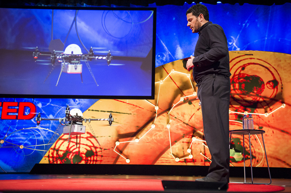
Andreas Raptopoulos and his colleagues at Matternet are attempting to create a network of drones that operate like the internet, only for tangible objects. This company — which sprung out of an idea surfaced at Singularity University in 2011 — aims to deliver items wherever they are needed, even if no usable roads go there.
Andreas Raptopoulos: No roads? There’s a drone for thatAndreas Raptopoulos: No roads? There’s a drone for thatIn today’s talk, Raptopoulos explains why a system like this is needed — to reach the one billion people worldwide who don’t have access to all-season roads. He also wowed the TEDGlobal 2013 audience when he landed one of Matternet’s drones on the TED stage, smack dab in the middle of the red carpet.
This week, he told the TED Blog more about the Matternet concept.
“At the inception of the internet, who would have anticipated the explosion of social networks, of machine-to-machine awareness, of distributed workflows, of the disruption of the music, video, photography and TV markets, Bitcoin or Snapchat?” he said. “The internet connects information, but it hasn’t connected all people. We’re designing the very edge of the web that can reach every unnavigable place where there’s human need.”
Matternet is a big idea. Below, read the real-world applications — two that Matternet has field tested and four that are still concepts.
Matternet has done this:
Delivered medical supplies to places in need. Matternet conducted one of its first field trials in Haiti in September 2012, testing three remotely piloted drones to see how they functioned in both urban and rural areas. The most fascinating use? Delivering medications to camps set up after the earthquake of 2010. “The system that is used currently is antiquated, to put it mildly: one big truck delivers one big box of medicine to a remote clinic every quarter,” Raptopoulus told the TED Blog. “It’s quite inefficient and very wasteful. There is no tracking, no information on if the medicine is used or not — and it’s very hard to predict demand and real needs for medicine in some part of the country. So the application we’d like to see there is routine, just-in-time logistics of much more discrete packages, exactly when you need them.” He stresses: “In places of extreme need … the aim should be to leapfrog rather than try to catch up on old practices and systems.”
Delivered supplies, information and diagnostic tools between medical centers. Around the same time, Matternet ran its second field test in the Dominican Republic, flying supplies and diagnostic tools from big healthcare centers to smaller ones in remote areas, and zipping samples back for analysis. They hope to turn this test into a year-long project to improve healthcare service for the poor and low-income populations of Samaná, where 60 percent of people live in rural areas. Paola Santana, Raptopoulos’ co-founder at Matternet, told the TED Blog, “We’re working with one of the big development banks in the region to fund this project.” And while they haven’t field tested there, Matternet has also thought a lot about Lesotho, and how Matternet could connect HIV/AIDS clinics there to provide better care and faster tests for patients. “While the battle against the disease is being won in most of the world, it’s being lost in Lesotho,” says Raptopoulos.
Matternet could do this in the future:
Help in disaster response. When an earthquake or tsunami hits, Matternet could potentially be a way to get supplies to people in need, before assistance in the form of manpower can arrive. Raptopoulos asks, “Can we help immediately after a disaster with first response? Instead of sending one big helicopter out, can we send 100 of these vehicles? After the first few days, can we rely on a system like Matternet to do routine transportation of small packages to get a country going again? Our answer is ‘yes.’”
Create a courier service that can’t get stuck in traffic. In both Haiti and the Dominican Republic, Matternet tried this, though on too small a sale to be considered a trial. “Port Au Prince has few roads and they are quite congested,” says Raptopoulos. “Several years after the earthquake, tens of thousands of people still live in temporary shelters and camps — as is typical in many regions that have experienced a natural disaster.” As for Santo Domingo, he says, “It’s an emerging city, growing quickly, and roads can get very congested in peak hours.” Now, to get hypothetical, imagine this in megacities like New York or Tokyo.
Deliver food. Matternet could also be very effective for getting food and water to areas that need it, especially in times of disaster, war or crisis. The trick here will be increasing Matternet’s load size. Currently, it is able to transport a two-kilogram load, covering a ten-kilometer distance in 15 minutes. As the weight-bearing ability increases, this use will become more and more viable.
Support the freedom to live where there aren’t roads. Marc Shillum, Matternet’s Creative Director says, “People live far away from roads for many reasons. Some have no choice, some are seeking seclusion … That’s a whole load of people who also can’t access the world’s products, services or care. We want to bring fulfillment to where need exists rather than where roads end. The beauty of unmanned autonomous vehicles is [that there’s] no physical infrastructure. UAVs fly wherever there is air.”
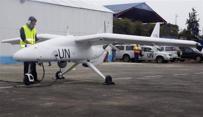
(Reuters) – United Nations forces in Democratic Republic of Congo launched unmanned aircraft on Tuesday to monitor the volatile border with Rwanda and Uganda, the first time U.N. peacekeepers have deployed surveillance drones.
The aircraft will be used to look out for threats from a host of local and foreign armed groups in the mineral rich east where Congo and U.N. experts have accused Rwanda and Uganda of sending arms and troops to back the recently-defeated M23 rebels, something both countries deny.
“The drones … will allow us to have reliable information about the movement of populations in the areas where there are armed groups,” U.N. Under-Secretary-General for Peacekeeping Operations Herve Ladsous said at the launch of the drones in Goma, the largest city in eastern Congo.
“We will survey the areas where there are armed groups, and we can control the frontier,” he added.
The U.N. mission has deployed two Falco drones manufactured by Selex ES, a unit of Italian defense group Finmeccanica.
One of the 5-metre (16-ft) long aircraft – painted white with the letters UN in black on its wings and tail – performed a demonstration flight for the crowd at the launch.
The drones will be flown out of Goma by Selex staff. They can fly for between eight and 14 hours and as far as 200 km (125 miles) from their base, according to the company.
U.N. peacekeepers have received widespread criticism for doing too little to end fighting in eastern Congo, a hilly and thickly forested region that Kinshasa has struggled to control during two decades of virtually constant conflict.
But the drone deployment comes after the peacekeepers helped defeat M23, the most serious rebellion of President Joseph Kabila’s 12-year rule.
General Carlos Alberto dos Santos Cruz, commander of the U.N. force in Congo, said the drones would only fly over Congolese territory, as U.N. peacekeepers have no mandate to operate in neighboring countries.
Victory over M23 was the first time Kinshasa had militarily defeated a major uprising in the east. It was helped by strong U.N. support, major reforms in Congo’s army and intense diplomatic pressure on Congo’s neighbors to halt rebel support.
Congo and U.N. experts say foreign backing for M23 was significant. Following the defeat, experts are examining the origin of a significant stash of weaponry and trucks found at M23’s bases in hills along the Rwandan border.
The drones were due to be launched as early as September, in the hope of monitoring the conflict taking place on the border. However delays meant they arrived only after M23 was defeated.
While a final political deal with M23 is still being ironed out, Congolese and U.N. forces are now expected to turn their attention to the Rwandan Hutu FDLR rebel group and Ugandan ADF-NALU rebels, both of which are based in Congo’s east.
Vienna University of Technology’s ‘smartphone quadcopter’
With one possible exception, autonomous quadcopters are not something that you would expect to be inexpensive. A relatively cheap model may indeed be on its way, however. Designed by the Vienna University of Technology’s Virtual Reality Team, the tiny aircraft utilizes the processor and camera of an off-the-shelf smartphone.
The Vienna team, led by chief engineer Annette Mossel, programmed the quadcopter’s navigation software into the processor using an app.
Once in flight, the UAV uses the phone’s camera to identify QR-like coded squares placed on the floor within a room. These allow it to create a map of the room, so it can subsequently find its way around the space on its own. Ultimately, plans call for it to be able to identify actual objects naturally present in a room (such as tables and chairs) using a Kinect-style depth sensor, and create its map using those.
The smartphone bits and pieces are the most expensive components of the quadcopter, with all of its parts together worth less than €1,000 (US$1,333). It is hoped that eventually, a commercial descendant of the aircraft could be used for things such as monitoring illegal forest clearing in developing nations.
Perhaps its price could be brought down further if it came without a processor of its own, and users just docked their own smartphone into it – as is already the case with some small, wheeled robots.
Commercial drones will soon be populating U.S. airspace, and venture capitalists like Tim Draper are placing their bets.
Draper, an early investor in Hotmail, Skype and Baidu Inc., is now backing DroneDeploy, a startup that’s building software to direct unmanned aircraft on land mapping and the surveillance of agricultural fields. Draper even expects drones to one day bring him dinner.
Drones are moving from the military, where they’ve been used to spy on and kill suspected terrorists, to a range of civilian activities. Photographer: Leigh Vogel/Getty Images
“Drones hold the promise of companies anticipating our every need and delivering without human involvement,” Draper, 55, wrote in an e-mail. “Everything from pizza delivery to personal shopping can be handled by drones.”
Venture investors in the U.S. poured $40.9 million into drone-related startups in the first nine months of this year, more than double the amount for all of 2012, according to data provided to Bloomberg News by PricewaterhouseCoopers and the National Venture Capital Association. Drones are moving from the military, where they’ve been used to spy on and kill suspected terrorists, to a range of civilian activities.
Congress has directed the Federal Aviation Administration to develop a plan to integrate drones into U.S. airspace by 2015 and to move faster on standards for drones weighing less than 55 pounds.
It’s not just startups that are anticipating the changes. ConocoPhillips says that drones could be used to monitor ice floes and marine mammals in the Arctic. Entrants could also include established drone makers AeroVironment Inc. (AVAV), Boeing Co. (BA)’s Insitu unit and Israel Aerospace Industries Ltd. in Tel Aviv, according to Bloomberg Government.
Growth Coming
Sales of civilian unmanned aerial vehicles, or UAVs, will reach $8.2 billion within the decade, up from nothing today, according to Phil Finnegan, director of corporate analysis at researcher Teal Group, which tracks aerospace and defense.
“There’s going to be a lot of growth in this market,” Finnegan said.
While the capital invested in drone-related startups has surged, it’s still concentrated in just a few companies. Three startups account for all of the money raised in the first nine months of this year, compared with five in all of 2012.
Draper backed DroneDeploy through his Menlo Park, California-based firm, Draper Fisher Jurvetson. Airware, a startup in Newport Beach, California, raised $13.3 million earlier this year from investors including Andreessen Horowitz, Google Ventures and First Round Capital to develop customizable autopilots for UAVs that cost about $4,500 to $7,500, according to the company’s website.
Airware found it much easier to attract the attention of venture capitalists this year after testing the product with customers, said Chief Executive Officer Jonathan Downey.
Funding Environment
“We’d looked at raising money last year, and it was very different,” said Downey, who plans to move the company to San Francisco in January.
The business of drones still carries plenty of risks. UAVs will have to occupy parts of the airspace not used by airplanes, and investors don’t yet know what the rules will be. Concerns over privacy are most notable given the history of drones as tools used by the government and military.
The American Civil Liberties Union has warned of the possibility of a “surveillance society” spurred by drones. “The only way to avoid this dystopian future and prevent mass, suspicionless searches of the general population is to ensure that information collected by drones for one purpose cannot be used for another purpose,” Allie Bohm, a strategist for the ACLU, wrote in an August blog post.
Declining Costs
Andy Wheeler, a partner at Google Ventures, said drones are moving into the mainstream because of the steep drop in the cost of sensors, which have been mass produced for smartphones. The plunge in costs helped convince Google Ventures to invest in Airware as well as another drone-related startup, Wheeler said, declining to say which one.
“We are talking orders of magnitude lower than military technology,” Wheeler said, referring to the prices for commercial equipment.
While DroneDeploy is building software and Airware is developing systems, some startups are focusing on services. Matternet Inc., funded by Andreessen Horowitz, aims to use drones for delivery of items such as mail and medical supplies.
Bloomberg LP, the parent of Bloomberg News, is an investor in Andreessen Horowitz.
Firefighters and law enforcement officials are likely to be some of the early beneficiaries of the drop in costs, said Kent Goldman, a partner at First Round Capital in San Francisco.
“I see a bright future for non-military applications,” he said.